Live Aurora Map & Forecast Tracker - Northern Lights Tonight
Track aurora visibility across 1013 locations. Current KP 2.0 — weak activity. Includes clouds, moon phase, and darkness.

Source: NOAA Space Weather Prediction Center. Updated every 30 minutes.
🌟 Where Aurora is Visible Right Now
No locations with visible aurora right now. Check back soon or enable notifications in the app.
What is the KP Index?
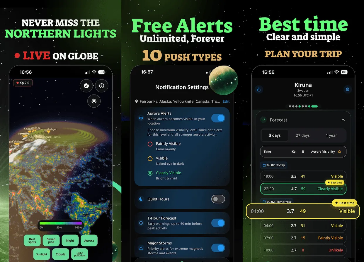
The KP index measures geomagnetic activity on a scale from 0 to 9. Higher KP means stronger aurora that can be seen further south from the magnetic poles.
KP 0-2: Weak activity — visible only at very high latitudes (Fairbanks, Tromsø)
KP 3-5: Moderate — visible in mid-latitudes (Reykjavik, Yellowknife, Anchorage)
KP 6-7: Strong — visible in lower latitudes (Seattle, Edinburgh, Southern Canada)
KP 8-9: Extreme — visible in southern regions (rare events, New York, Paris)
Important: We factor in more than just KP — cloud cover, moon phase, and darkness all affect visibility. Even with high KP, you won't see aurora if clouds block the sky or during full moon.
Aurora Map Layers in AuroraMe
The AuroraMe app includes 7 interactive map layers that go far beyond the static NOAA aurora map shown above. Each layer helps you find the perfect northern lights viewing conditions.
Aurora Probability
Real-time aurora oval overlay showing where northern lights are visible right now, updated every 30 minutes from NOAA OVATION data.
Cloud Cover
Hourly cloud forecast so you can find clear skies nearby. No point chasing aurora behind thick clouds.
Light Pollution
Bortle scale overlay helps you escape city glow and find dark-sky locations where aurora is visible to the naked eye.
Moon Illumination
Moon phase and brightness data. A full moon washes out faint aurora — plan around lunar cycles for best results.
Darkness & Daylight
See exactly when astronomical darkness begins at your location. Aurora needs dark skies to be visible.
Precipitation
Rain and snow forecast layer. Precipitation means clouds, and clouds mean no aurora viewing.
Temperature
Plan your outdoor aurora watch with temperature forecasts. Northern lights hunting often means hours in the cold.
All 7 layers are free — no premium subscription required for map access.
Get Alerted Before Aurora Appears
Push alerts 20–90 min before northern lights. 72h forecast, cloud cover, 11 years of historical data.
- Real-time KP & Weather
- Push Alerts
- Live Aurora Map
- Cloud Cover Forecast
Aurora Map Questions
Want the broader aurora borealis forecast, not just the live map? Start with Aurora Borealis Forecast for tonight's outlook, storm context, top city pages, and forecast tools in one place.
Where can I see a live aurora map?
NOAA publishes a 30-minute aurora forecast map (shown above), but it only shows probability — not clouds or light pollution. The AuroraMe app combines all 7 layers into one interactive aurora map with real-time updates, so you can see exactly where northern lights are visible right now.
What is the best aurora forecast map?
The best aurora map combines space weather data with local conditions. NOAA's OVATION model provides the aurora oval, but you also need cloud cover, light pollution, and darkness data. AuroraMe layers all of these onto a single map with location-specific forecasts for any location.
How accurate are aurora maps?
Aurora probability maps are most accurate 1-3 hours ahead (within KP ±0.5). Beyond 24 hours, accuracy drops significantly. AuroraMe refreshes data every 15 minutes from NOAA and GFZ sources, with automatic fallback if one source is unavailable.
Can I see cloud cover on an aurora map?
Yes — the AuroraMe app overlays hourly cloud cover forecasts directly on the aurora map. This is critical because clouds are the number one reason people miss aurora even during strong geomagnetic storms. The cloud layer helps you find clear-sky gaps nearby.
Do I need premium for the aurora map?
No. All 7 map layers in AuroraMe are completely free — aurora probability, cloud cover, light pollution, moon illumination, darkness, precipitation, and temperature. Premium unlocks unlimited locations and extra push notifications, but the full northern lights map is free for everyone.
Frequently Asked Questions
What is the Kp index?
The Kp index measures geomagnetic activity on a scale from 0 to 9, published by NOAA SWPC every 3 hours. Higher Kp means a larger auroral oval and aurora visible at lower latitudes. Kp 3+ is visible in northern Scandinavia, Kp 5+ reaches Scotland and northern US states, Kp 7+ can reach central Europe.
Can I see aurora tonight?
Aurora visibility depends on 5 factors: Kp index (geomagnetic activity), cloud cover, moon phase, hours of darkness, and your magnetic latitude. All five must align — even strong Kp activity is invisible behind clouds or during twilight. Check the forecast for your city to see if conditions align tonight.
What causes the northern lights?
Aurora borealis occurs when charged particles from the solar wind enter Earth's magnetosphere and collide with atmospheric gases. Oxygen produces green light (90–150 km altitude) and red light (above 200 km), while nitrogen creates purple and blue hues. Coronal mass ejections (CMEs) from the Sun trigger the strongest displays.
How does aurora forecasting work?
AuroraMe uses a 5-factor prediction model: real-time Kp index from NOAA SWPC, local cloud cover forecasts, moon phase and illumination, hours of darkness at your location, and magnetic latitude (which determines your minimum Kp threshold). These factors are combined into a single visibility status updated every 15 minutes.
When is the best time to see the northern lights?
The best season is September through March in the northern hemisphere, with peak activity around the equinoxes (September-October, February-March) due to the Russell-McPherron effect. The best hours are 10 PM to 2 AM local time, when geomagnetic substorms peak. Solar Cycle 25 is near its maximum in 2025-2026, making this period exceptionally active.
What Kp level do I need for my location?
Your required Kp depends on magnetic latitude. The formula is roughly: Required Kp = (66 - Magnetic Latitude) / 2. For example, Tromsø (67.4° MLAT) needs just Kp 1, Edinburgh (58.2° MLAT) needs Kp 4, and London (53.4° MLAT) needs Kp 6. Check any city page for the exact Kp threshold calculated from its magnetic latitude.

App Store

Google Play
Scan to downloadAuroraMe — Free Aurora Alerts
Download on theApp Store
GET IT ONGoogle Play
App Store
Google Play